Southcentral Alaska gets hit by early season record-breaking snowfall
Moderate to heavy snow fell across much of Southcentral, closing schools and making for dangerous road conditions
ANCHORAGE, Alaska (KTUU) - Anchorage and portions of the Mat-Su and Kenai Peninsula are dealing with the aftermath of the first major winter storm of the season. The storm brought record-breaking snow to the region.
UPDATE - 5:15 p.m. Thursday
Another round of snowfall has forced a restart to the city’s plowing plan.
Municipal officials said in a statement on the city website that snowplowing on Anchorage’s residential streets will be put on pause at 5 p.m. Thursday so that crews can focus on clearing the main traffic routes in town. Those roads will begin getting plowed at 8 p.m. Thursday.
After the main roads are clear, city crews will return to residential streets.
The city had previously said that it takes 84 hours under normal snowfall conditions to complete a full plowout, although additional snowstorms can restart that process.
UPDATE - 9 p.m. Tuesday
Anchorage Mayor Suzanne LaFrance spoke with anchor Rebecca Palsha on Tuesday about the municipality’s response to record-breaking snow in the region. Watch the full interview below.
UPDATE - 7 p.m. Tuesday
UPDATE - 3:30 p.m. Tuesday
Anchorage Municipal Street Maintenance announced that their snow plow crews will begin plowing residential streets at 8 p.m. on Tuesday.
Crews first plowed arterial and collector routes and will move to residential streets Tuesday night.
Mayor Suzanne LaFrance posted in an email that after focusing plowing crews on West Anchorage, where snowfall was the heaviest late Monday night, the city had to begin replowing roads after more snow fell early Tuesday morning.
The mayor said 25 trucks were tasked with clearing downtown Anchorage overnight, with residential streets to follow.
UPDATE - 11 a.m. Tuesday
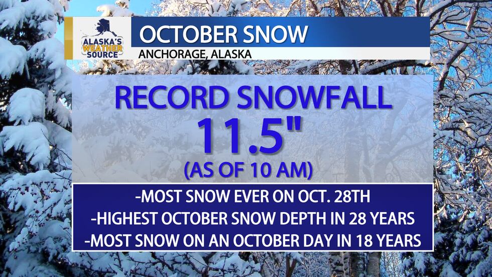
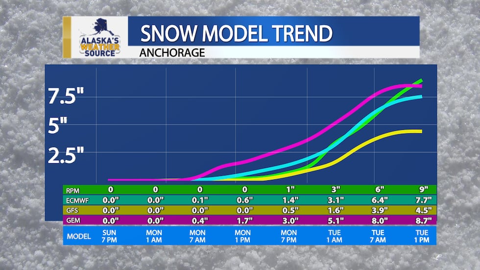
As of 10 a.m., 11.5 inches of snow was measured for Anchorage’s official snowfall total. The 6″ that fell on Monday beat the previous record of 4.8″ set in 1982.
This is also the first time Anchorage has seen 6″ of snow on an October day in 18 years.
With the additional 5.5″ that fell since midnight, this is now the most snow we’ve had on the ground for Alaska’s largest city in the month of October in 28 years.
UPDATE - 6:20 a.m. Tuesday
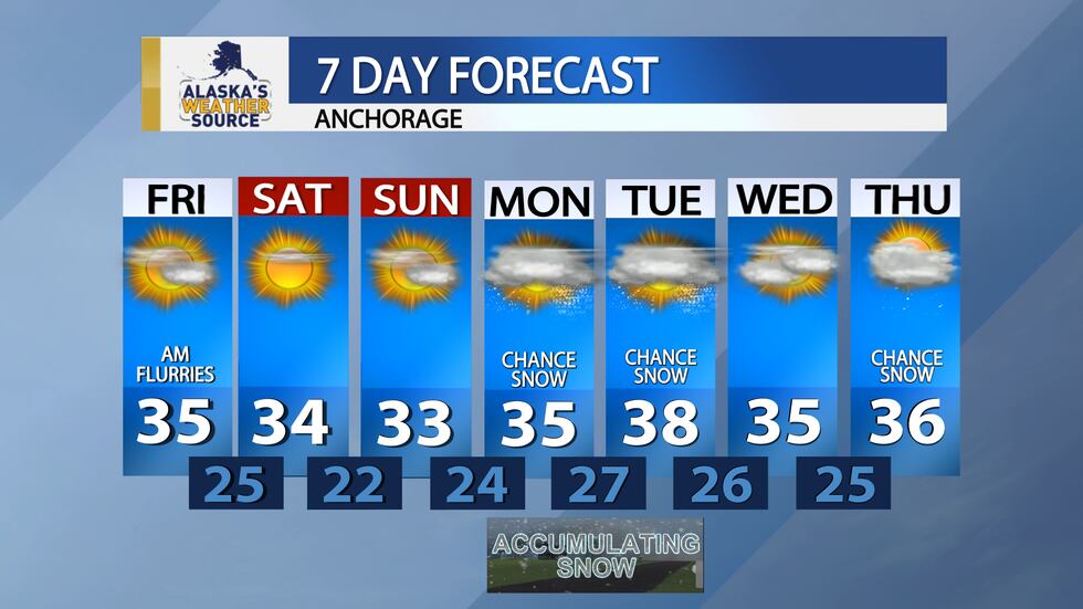
Most schools across Southcentral — including practically the entire Anchorage School District — are closed Tuesday to in-person learning due to snowfall impacts.
UPDATE - 4:30 a.m. Tuesday
A Winter Storm Warning is now in effect for Anchorage until 1 p.m. Tuesday. Six inches of snow fell Monday in Anchorage and an additional 3 to 6 inches is expected Tuesday morning.
A Winter Storm Warning means severe weather could make travel hazardous. The heavy snow will also reduce the visibility so drive with your headlights on and give the person in front of you some extra space.
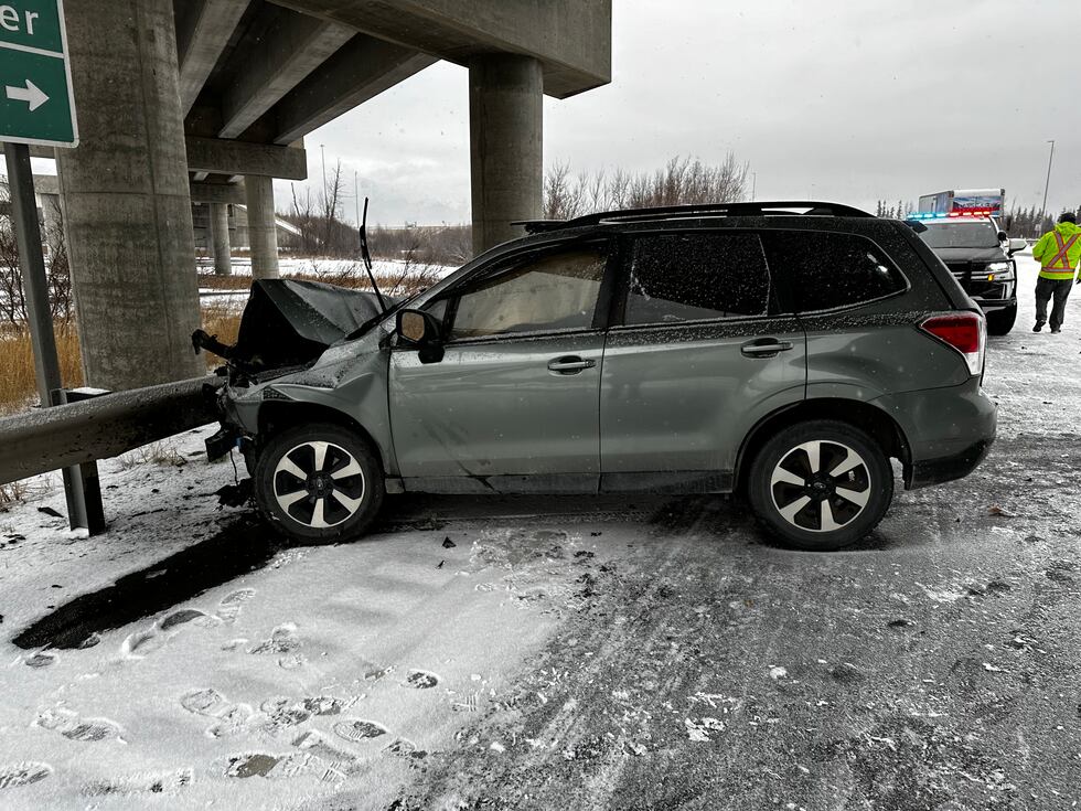
The Anchorage Police Department says as of 4 a.m. they have responded to 13 accidents with injuries, 64 accidents without injuries and 57 vehicles in distress.
UPDATE - 10:50 p.m. Monday
The Anchorage Police Department said in an email Monday evening that from 10 a.m. to 10 p.m. on Monday, it tracked 44 vehicles in distress, 54 crashes and 12 crashes with injuries.
This is not atypical compared to years prior, according to APD Sgt. David Noll, who recommended that people be cautious about inadvertently downplaying what could be a serious crash when it comes to deciding between calling 911 versus 311 to report.
“If it’s possibly an emergency related to a vehicle that’s gone off the road, you should call 911,” he said. “If you know that there’s no person in the vehicle, there’s no emergency at the time, that’s a great opportunity to call 311.”
However, if you are not absolutely certain that no one is in a vehicle that is stranded, damaged, or in another questionable condition, “err on the side of caution,” Noll said. “Treat it like an emergency, and call 911.”
UPDATE - 7:30 p.m. Monday
Snow is increasing across much of Southcentral. Nikiski and Kenai have reported 4-4.5 inches of snow as of 7 p.m. Locations from Anchorage to Fishhook and Big Lake have seen 1-3 inches and climbing. Heavy snow will continue overnight through Tuesday morning for Kenai, Anchorage, and the Mat-Su. These areas should be prepared for 6-12″ of snow through Tuesday afternoon.
UPDATE - 6:10 p.m. Monday
The Kenai Peninsula Borough School District said it has “a thorough process to determine whether a two-hour delay or school closure is necessary.”
Kari Lee Dendurent says given how much land the district encompasses, final determinations aren’t typically made until the morning of the day affected.
UPDATE 5 p.m. Monday
As the evening rush hour begins, the Anchorage Police Department is reporting 37 vehicle crashes, including six with injuries.
Police also reported 25 vehicles “in distress” since 10 a.m. Monday.
Alaska Department of Transportation leaders say as Southcentral Alaska deals with the season’s first major snowstorm, they are better prepared over last season.
So far, Anchorage has officially seen one inch of snow through Monday afternoon, but meteorologists expect that number to rapidly grow through the evening and overnight hours.
UPDATE 12 p.m. Monday
Due to inclement weather, the Matanuska-Susitna Borough School District have canceled after-school activities in regions 3, 4, 5 and 6.
Cancelations in regions 1 and 2 will be determined by the school.
No cancelations have been announced in Region 7.
UPDATE 8 a.m. Monday
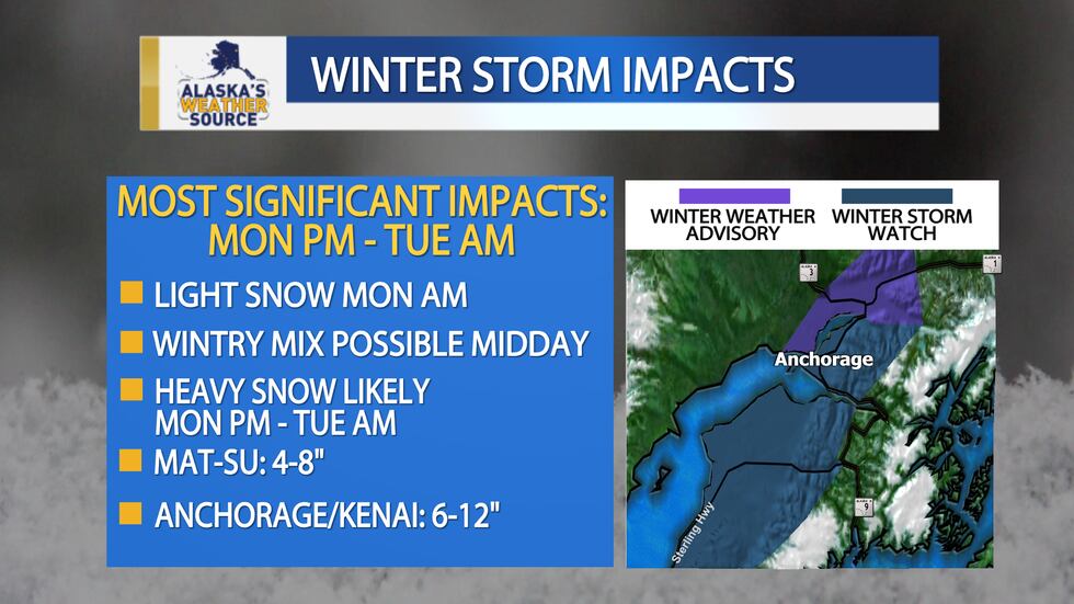
Snow is expected to develop through the morning around Southcentral Alaska. Anchorage is under a Winter Weather Advisory starting at 10 a.m. Monday with 6 to 9 inches of snow possible. Higher totals could hit parts of the Hillside by Tuesday afternoon.
The western Kenai Peninsula is also under a Winter Storm Warning for heavy snow and hazardous travel conditions starting at 10 a.m. Monday and lasting until 1 p.m. on Tuesday. Temperatures will be well above freezing so look for a rain-snow mix for much of the Kenai on Monday. This will likely freeze overnight into Tuesday morning.
A Winter Storm Warning will go into effect at 10 a.m. Monday for the Mat-Su from Wasilla to the west and Talkeetna south. Snow totals of 9 to 12 inches are expected across the region. Snow totals will get lighter heading east near Palmer where you can expect to see 2 to 5 inches of snow from this storm.
The main challenges will be the Monday night and Tuesday morning commutes. Leave extra space and give yourself extra time on the streets.
UPDATE 4 p.m. Sunday
As this storm moves east overnight, light snow will begin falling across Southcentral, with up to an inch expected by early Monday morning in Anchorage, the Mat-Su, and the western Kenai Peninsula.
Snow will continue through the afternoon, at times mixing with rain. 1-4″ of additional snow should be expected by the afternoon. With temperatures hovering near freezing Monday afternoon, be prepared for icy and slushy conditions.
The heaviest precipitation will likely fall late Monday into Tuesday morning. Temperatures will drop back below freezing, with an additional 3-6″ of snow likely through Tuesday morning.
Anchorage and Kenai should be prepared for 6-12″ of snow, with 4-8″ likely in the Valley. Snow totals will vary based on elevation and where the heaviest band of snow sets up on Tuesday afternoon.
This storm contains a significant amount of moisture, bringing wet conditions to most of Southcentral. A heavy rain/snow mix is likely in Homer and Seward, with heavy snow likely in the mountains.
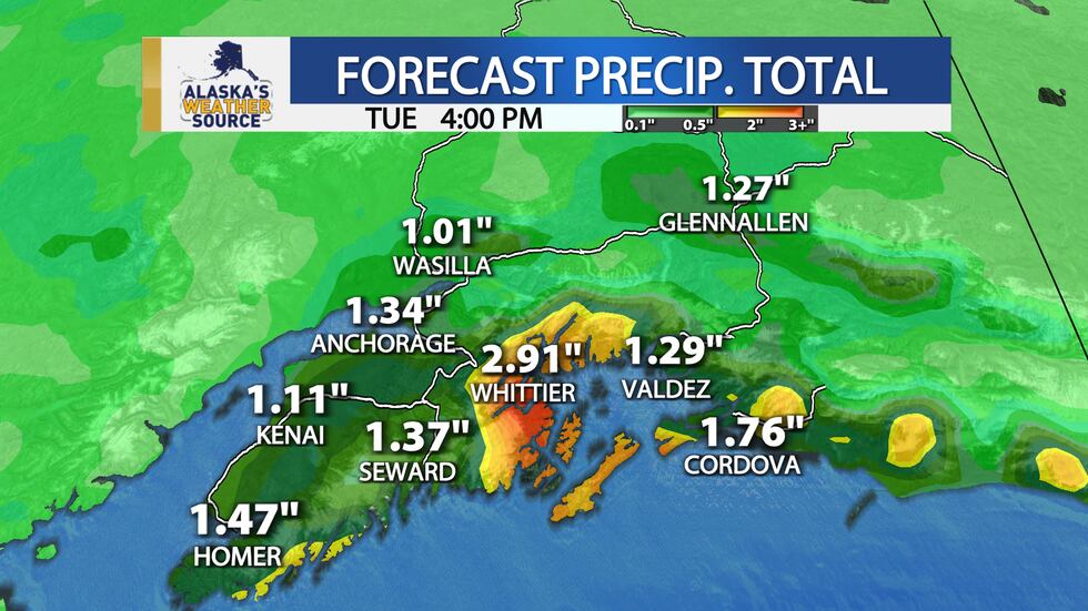
While there is still some uncertainty as to where the heaviest snow will fall, models are in good agreement that significant snow is likely from Kenai to Anchorage and into the Mat-Su late Monday through Tuesday.
Stay tuned to the Alaska’s Weather Source team for the latest on this developing forecast.
Download the Alaska’s Weather Source app for the latest forecast, weather alerts, and much more.
iOS: Click here to download now! | Android: Click here to download now!
4 p.m. Thursday
For the first time this season, several inches of snow are in the forecast for Anchorage.
The storm is still developing in the far western Pacific but is expected to track east into Southcentral Alaska by Monday. The current track brings snow into the Anchorage Bowl mid-day, continuing through Tuesday.
Temperatures at that time will likely be at or below freezing, and models are currently showing enough moisture when the storm reaches Anchorage for several inches to fall across the city by Tuesday morning. Temperatures will likely climb above freezing during the day, which means a wintry mix of snow and rain is possible through the afternoon.
With the storm still forming and several days out, this forecast could still change significantly before that time, but preparations should be made now for an icy and snowy commute Monday night through Tuesday night.
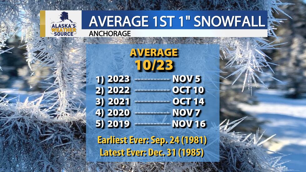
Anchorage‘s first official snowfall this season was Oct. 10 when 0.4″ of snow fell, but the city has yet to see more than an inch.
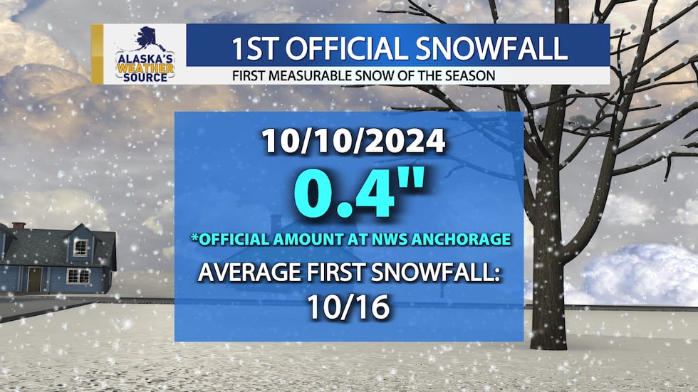
The average first snowfall of an inch or more is Oct. 23 in Anchorage. Last year, the city didn’t see that much snow until Nov. 11, and for three out of the last five seasons, the first snowfall of an inch or more didn’t happen until November.
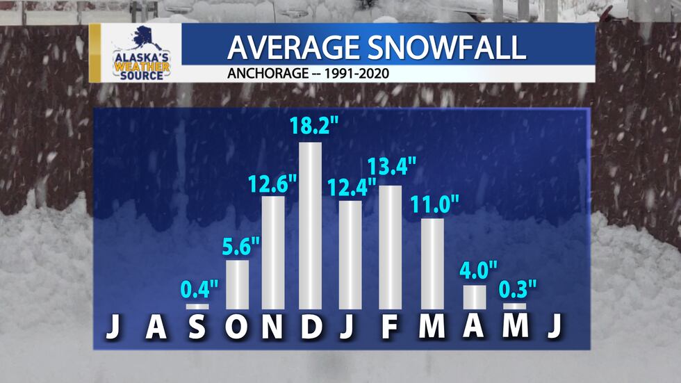
On average, more than five inches of snow falls in October, with more than a foot expected each of the following months through February, and often in March as well.
Stay tuned to the Alaska’s Weather Source team for the latest on this developing forecast.
Download the Alaska’s Weather Source app for the latest forecast, weather alerts, and much more.
iOS: Click here to download now! | Android: Click here to download now!
Copyright 2024 KTUU. All rights reserved.