Landslide above Portage Lake is on geologists' radar as tsunami threat
ANCHORAGE, Alaska (KTUU) - A landslide near the southern end of Portage Lake is on geologists' radar as a tsunami threat.
There are concerns debris from the slide could fall into the lake, creating a tsunami that could be 50 feet tall near the area of the Begich, Boggs Visitors Center.
“There’s a lot of things we don’t know,” Alaska geologist Bretwood “Hig” Higman said. “And some of this is because reality could play out in various different ways and some of this is because the science isn’t there.”
The slow-moving landslide is above the front of the glacier, he said.
“If you were looking at the glacier on the right, this slope on the right has started crumbling, and a lot of it is moving slowly downward,” he said.
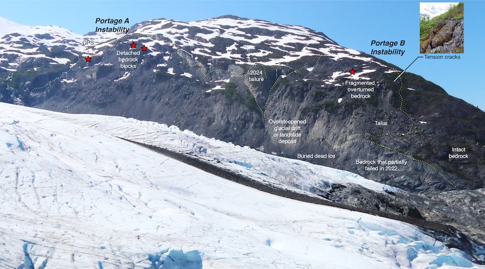
“Parts of it are falling off abruptly but they’ve been small parts so far. And the worry is that a big chunk could come loose. And if that hit the water, it could generate a tsunami in the lake that could be very large.”
There’s still a lot to learn about the situation, Hig said. He has been studying it since 2022.
“It’s the sort of mass that could produce a tsunami that would be many hundreds of feet tall in some places and certainly tens of feet tall throughout the margin of the lake. And so, that’s why we’re really worried about it — it is big,” he said. “Is it record-breaking in the world? Definitely not. Is it bigger than most landslides you encounter? Definitely.”
Alaska Landslide Hazards Program Manager Mort Larsen agrees the slide warrants close eyes.
“That’s a major corridor system, it’s a recreational system so it’s definitely something that people need to pay attention to, something that needs to be observed and monitored to a certain degree,” Larsen said, “so the right information gets to the decision makers so they can make decisions on relaying that information to the public.”
Hig said the tsunami modeling still needs more work for scientists to understand exactly where the water would go, but he’s sure there’s a risk.
“Reality is that the visitor center is at risk and that the valley is at risk. I have high confidence in that,” Hig said.
“I wish I could say with great confidence exactly how much risk that was, and I can’t. We’ve done some initial analysis trying to figure that out,” Hig said about spending time in the area.
Hig is also concerned about the risk to nearby infrastructure – including the tunnel into Whittier, the highway, rail lines and power lines.
“Some very bad cases would involve something that would sweep all the way down the valley, would endanger everything in Portage Valley,” he said. “Some of the models that we’ve run, which are very limited so far, do show the wave reaching the Portage end of the tunnel, and because it goes downhill, then the water could run through it, down that tunnel.”
There’s a range of possibilities that could happen, with a lot of uncertainty, Hig said.
“We keep getting surprised by how variable the behavior of these landslides are,” Hig said. “We could go 100 years from now, we could sit down again [as] very old people and maybe say, ‘Well, it turned out it didn’t happen.’”
He said to some, the risk might be worth it.
“People choose to take risks, and I think that’s a fine choice to make. I think it’s important that people recognize that spending time in Portage Valley is taking a risk,” Hig said.
He said in the short term, he is working on a plan of how to track the landslide’s deformation in real-time, and the scientists working to monitor the landslide are working on the project in their spare time.
Alaska Division of Geological & Geophysical Surveys (DGGS) and USGS scientists are studying a landslide above Portage Lake, Research Physical Scientist Dennis Staley said in a statement in mid-December on behalf of USGS.
DGGS scientists have been collecting topographical data over a period of several years, according to Staley.
He said there is not enough information available to estimate what the probability is for the landslide to fall or what impact a potential tsunami could have.
“With the logistical support of the U.S. Forest Service, scientists at the USGS and DGGS are collaborating to gather information about the location, size, and movement history of the numerous landslides in the region, including those above Portage Lake,” Staley said.
Editor’s note: A request for comment from Alaska’s News Source to the USGS was not responded to at the time of this original report. However, a statement was provided on Dec. 17. Information from that response has been added to the article.
See a spelling or grammar error? Report it to web@ktuu.com
Copyright 2024 KTUU. All rights reserved.